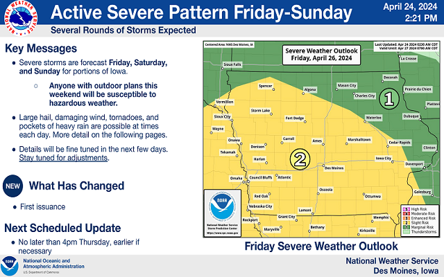
Drought monitor show some deterioration in the last week
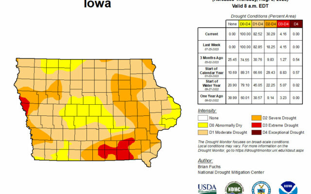
DES MOINES — The latest Drought Monitor report shows a little deterioration in the conditions in the state in the last week.
Iowa Department of Natural Resources hydrologist Tim Hall says that doesn’t reflect the most recent storms in western and southern Iowa. “The rain that came in southern Iowa over the last two days came after the cutoff for the Drought Monitor,” he says.
The monitor shows a large part of eastern Iowa has moved from moderate to severe drought. Hall says the rains we’ve had recently will help. “Over the last month things have remained relatively stable across the state,” he says. “We ended up behind normal for rainfall in July, although we did get more rain in July than we got in June, so that’s good.”
Hall says rainfall in mid July did impact the level of drought, but we haven’t seen consistent enough rain yet to get rid of all the concern. “We’re sort of still on the edge of drought that could become much more significant but it hasn’t gotten appreciably worse,” Hall says.
He says the recent rains helped with the much needed soil moisture. “The other thing that’s working in our favor is that in about another month or so, we’ll get through the peak demand time of the year. So the demand for water will start to drop as we move from August into September. And that certainly helps to preserve whatever waters in the system,” according to Hall.
The weather outlook has indicated we could see more rain in August, which would also help the drought situation.
Here in north-central Iowa, a majority of the area is in the “D-1 Moderate Drought” category. There is a small area of “D-2 Severe Drought” in far northeastern Worth and far northwestern Mitchell counties. Far northwestern Winnebago and northern Kossuth counties are in the “D-0 Abnormally Dry” category