Large Spring Storm Sunday Into Tuesday ❄☔⛈🌬
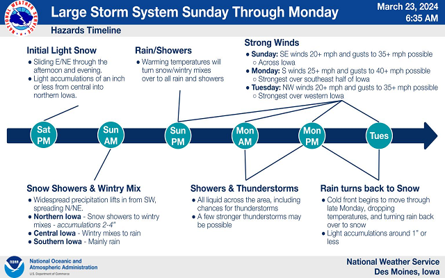
From today into Tuesday, quite a bit expected to transpire over the region, including a couple opportunities for snow, widespread rain, a few thunderstorms, and some strong and gusty winds.
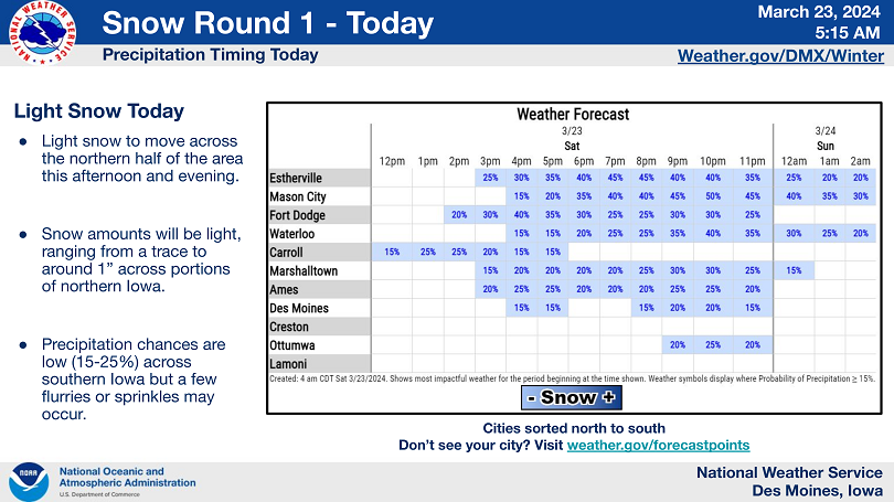
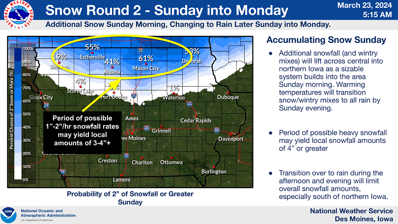
It all kicks off today with potential for some light snowfall, with best shot at light accumulations over northern areas. Then things ramp up Sunday with increasing southeasterly winds and snow and wintry mixes to start the day before transitioning over the all rain. Snowfall rates of 1 to 2 inches per hour are possible over the northern parts of Iowa so we will see a quick 2 to 4 inches before the snow transitions to rain, with thunderstorms possible on Monday.
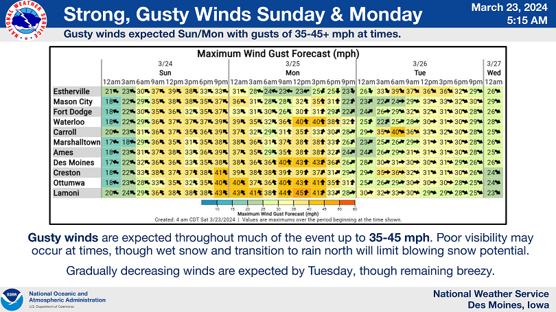
Monday will also see the chance for a few storms while winds remain strong and gusty out of the south. Then a cold front pushes through Tuesday that will have breezy northwest winds and push some light snow back through the area. Wind gusts may approach or exceed 35 to 40 mph at times.
A Winter Storm Watch is in effect for Freeborn and Fairbault counties in southern Minnesota. Here is the latest on the watch from the National Weather Service.
…WINTER STORM ARRIVES SUNDAY BRINGING HEAVY WET SNOW AND STRONG WIND… .Light snow will develop Saturday night, but the main storm system will arrive on Sunday. A heavy band of snow will develop across northern Iowa Sunday morning, and lift up from the south. Snowfall rates of 1 inch per hour are likely, with 2 inches per hour possible. Winds will be out of the east at 25 to 35 mph, which will lead to very low visibility. Snow will become more widespread throughout the day on Sunday. Winter Storm Watches and Warnings are in effect during this time. On Sunday night, warmer air will cause snow to change over to rain across southern Minnesota, and this warm air will expand on Monday. Areas in eastern Minnesota and western Wisconsin could also change over to rain. Areas in western Minnesota will likely remain all snow. There is uncertainty on where the rain, snow line will set up. On Monday night and Tuesday, colder air will move in causing a change over back to snow across much of the region. A couple more inches of accumulation is possible, but the main concern is for strong northwest winds of 30 to 40 mph to cause blowing snow across western Minnesota. The system will exit on Tuesday.
…WINTER STORM WATCH IN EFFECT FROM SUNDAY MORNING THROUGHSUNDAY EVENING…
* WHAT…Heavy wet snow possible. Total snow accumulations of 2 to 6 inches possible. Winds could gust 30 to 35 mph.
* WHERE…Martin, Faribault and Freeborn Counties.
* WHEN…From Sunday morning through Sunday evening.
* IMPACTS…Travel could be very difficult. High snowfall rates and patchy blowing snow could significantly reduce visibility.
* ADDITIONAL DETAILS…There is uncertainty on whether you’ll see a heavy snow or a cold rain.
PRECAUTIONARY/PREPAREDNESS ACTIONS…
Monitor the latest forecasts for updates on this situation.