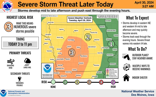
Severe Weather Possible Later Today
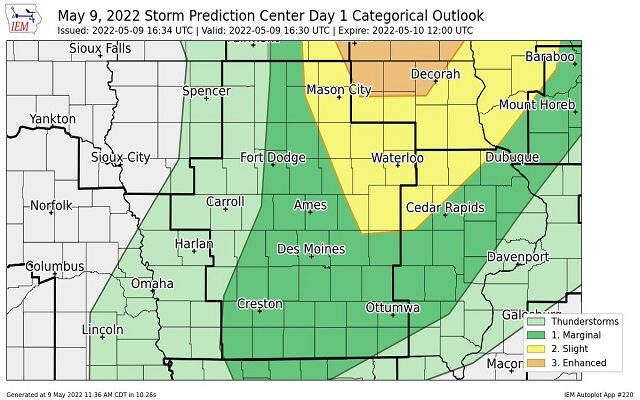
Portions of northern Iowa and southern Minnesota have been upgraded to an “Enhanced Risk” of severe weather later today, with other parts now under a slight risk. Large hail, damaging winds and a few tornadoes are all possible.
Remain weather aware later today and stay with us for the latest severe weather information.
11:36am CDT #SPC Day1 Outlook Enhanced Risk: across southeast MN, far west-central WI, and far northeast IA. https://t.co/GtEvHQ3UxE pic.twitter.com/nHLNtAdpZh
— NWS Storm Prediction Center (@NWSSPC) May 9, 2022
More thunderstorms could redevelop later this afternoon along and east of I-35. A few storms could be severe and produce large hail, damaging winds, and tornadoes. Please have a way to receive severe weather watches and warnings! #mnwx #wiwx pic.twitter.com/RdFAyeQYyd
— NWS Twin Cities (@NWSTwinCities) May 9, 2022